
Geographical profiles

 Geographical profiles
The geographical profiles provide a one stop shop for information on various levels of sub-city geographies from LSOA, wards and localities. These profiles pull together information across a range of topics, including demography, economy, community safety, health, education and social care, to better understand local population need across Southampton.
Lower Layer Super Output Area profiles
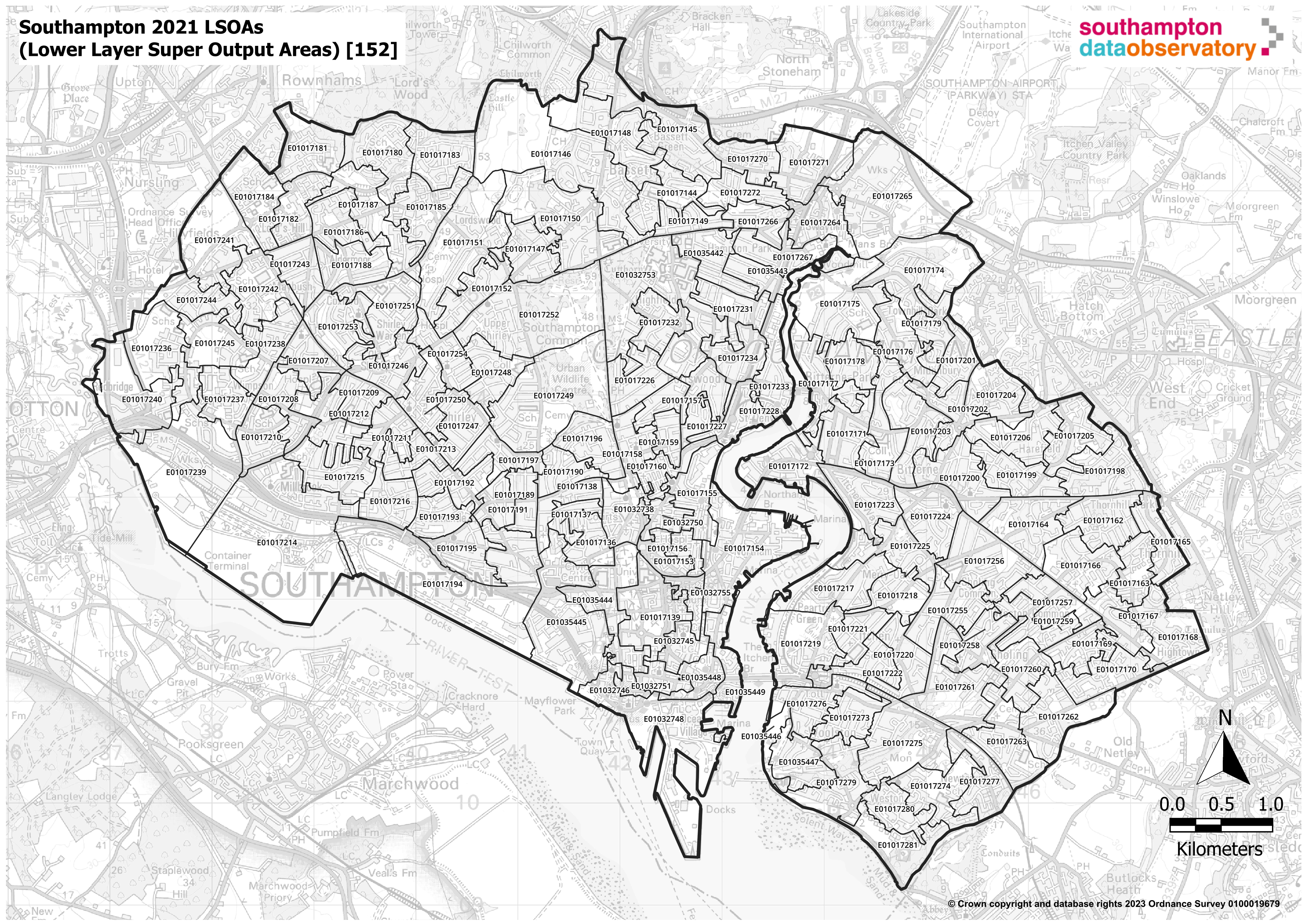 These geographical profiles include analysis of Lower Layer Super Output Areas (LSOAs). LSOAs are the most frequently used small area Census geography and have an average population of 1,500, there are 152 LSOAs in Southampton.
More information on these 2021 Census geographies is provided by the Office for National Statistics (ONS).
The geographical profiles dashboard include profiles for each of the 152 Southampton LSOAs. These profiles are designed to meet the need for information and intelligence at the local level in the city and form part of the Single Needs Assessment for Southampton. The profiles pull together information across a range of topics to better understand the local population need at sub-city geographies.
The sub-city LSOA profiles are available in the geographical profiles dashboard available below.
Geographical profiles dashboard
Visualisation
 Southampton wards
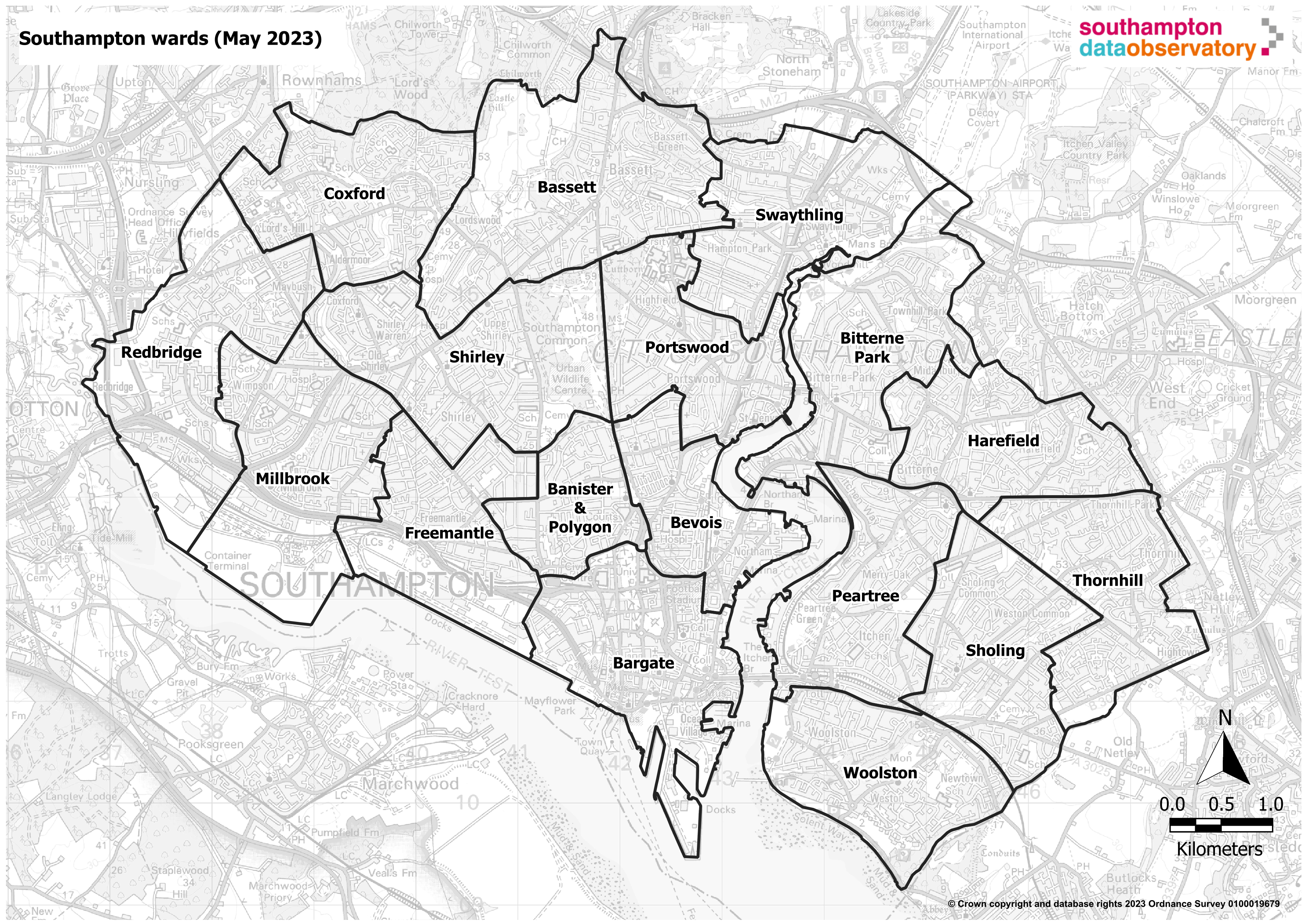
A ward is an area within a local authority used for electoral purposes. There are 17 electoral wards in Southampton, each with three councillors, a total of 51 councillors overall. Each ward has between 13,500 residents (Harefield) and 18,700 residents (Banister & Polygon).
Ward profiles have been created for each ward in Southampton and are included in the geographical profiles dashboard available below. The dashboard provides data for each ward covering a range of data indicators and giving the ability to look at individual wards, compare wards or look at tends in data associated with the wards.
Geographical profiles dashboard
Visualisation
Southampton localities
 There are 6 localities in Southampton, profiles have been produced for each locality. These profiles pull together information across a range of topics to better understand the local population need at sub-city geographies. These localities combine the 17 electoral wards in Southampton into six locality areas, five of the six areas combines three wards and one combines two wards.
These locality profiles are a local Southampton City Council service area geographical areas sharing the same boundaries as the neighbourhood areas, these profiles are available on the Neighbourhood area profiles page.
The locality profiles are part of the interactive geographical profiles dashboard available in the resouces section below.
Resources
Geographical profiles dashboard
This dashboard provides profiles for neighbourhoods (LSOAs), 17 electoral wards and 6 localities in Southampton. These profiles have been produced to meet the need for information and intelligence at the local level in the city and form part of the Single Needs Assessment for Southampton. These profiles pull together information across a range of topics including demography, economy, community safety, health, education and social care to better understand the local population need at sub-city geographies.
Geographical profiles dashboard
Visualisation
Geographies dashboard
This dashboard draws together a selection of interactive maps on various topics all in one place. These maps range from geographical boundary maps and points of interest for Southampton.
Geographies dashboard
Visualisation
Census 2021 interactive dashboard
Users can access a range of Census data across different topic areas including population, education, identity, housing, health and work. With the ability to view benchmarking between Southampton and ONS comparators and mapping of data by Census geographies, such as lower layer super output areas (LSOA) a neighbourhood of around 1,500 residents.
Census 2021 dashboard
Visualisation
Southampton population dashboard
The dashboard presents a range of population data to provide intelligence on Southampton's resident and GP registered population to help drive strategic decision making. Data in this dashboard is compiled from a range of publicly available sources. Including Small Area Population Forecasts (SAPF), Mid-Year Population Estimates (MYE), Subnational Population Projections (SNPP) and GP Registered Populations. Please note that SAPF figures in the dashboard are the sum of all Lower Level Super Output Areas (LSOAs) and may not be the same as other published figures.
Southampton population dashboard
Visualisation
ONS - Subnational indicators explorer
Compare a local authority and the UK average (median) local authority by different indicators, such as weekly pay and healthy life expectancy.
ONS - Subnational indicators explorer
Visualisation
OCSI - Hyper-local Need measure
Developing a measure of Hyper-local Need: neighbourhood level data to inform Labour’s key missions. The ‘Hyper-local Need measure’ has been created to help demonstrate the ways in which complex social and economic challenges cluster in communities around the country.
OCSI - Hyper-local need measure
Website
OCSI - Local Insight: Hyper Local Needs Measure map
Visualisation